Floor Plan

A
floor plan is a architectural map drawn to scale to show the
relationships between rooms, spaces, and other physical features at one
level of a structure. Dimensions are usually drawn between the walls to
specify room sizes and wall lengths. Floor plans will also include
details of fixtures like sinks, water heaters, furnaces, etc. Floor
plans will include notes to specify finishes, construction methods, or
symbols for electrical items.
 Terminal area charts are used in US and Canadian aviation. These are
aeronautical charts used for navigation under Visual Flight Rules that
show areas surrounding major airports.
These charts depict topographic features and other information of
interest to aviators flying visually, including major landmarks, terrain
elevations, visual navigation routes, ground-based navigation aids,
airports, rivers, cities, and airspace boundaries.
Terminal area charts are used in US and Canadian aviation. These are
aeronautical charts used for navigation under Visual Flight Rules that
show areas surrounding major airports.
These charts depict topographic features and other information of
interest to aviators flying visually, including major landmarks, terrain
elevations, visual navigation routes, ground-based navigation aids,
airports, rivers, cities, and airspace boundaries.
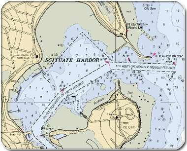 Nautical
charts map maritime areas and surrounding coastal regions. Most
nautical charts like the one above show depths of water and heights of
land, seabed features, and navigational hazards. Some charts also show
tides, currents, harbours, buildings, and bridges.
Nautical
charts map maritime areas and surrounding coastal regions. Most
nautical charts like the one above show depths of water and heights of
land, seabed features, and navigational hazards. Some charts also show
tides, currents, harbours, buildings, and bridges.
Terminal area charts are used in US and Canadian aviation. These are
aeronautical charts used for navigation under Visual Flight Rules that
show areas surrounding major airports.
These charts depict topographic features and other information of
interest to aviators flying visually, including major landmarks, terrain
elevations, visual navigation routes, ground-based navigation aids,
airports, rivers, cities, and airspace boundaries. Nautical
charts map maritime areas and surrounding coastal regions. Most
nautical charts like the one above show depths of water and heights of
land, seabed features, and navigational hazards. Some charts also show
tides, currents, harbours, buildings, and bridges.
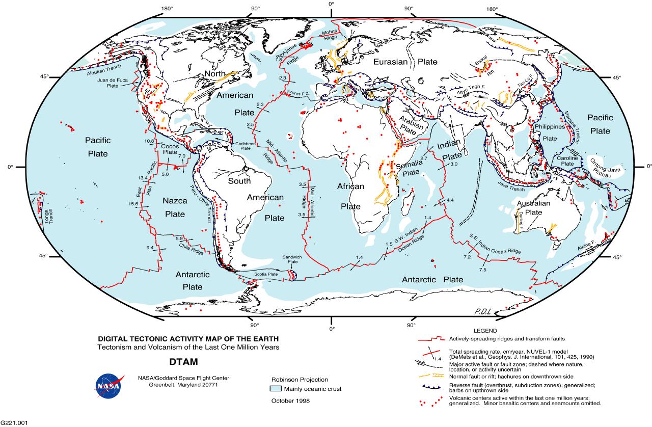
A
tectonic map is a representation of structural elements related to the
tectonic history of the upper crust of a planetary body. The different
structural areas and their separate elements such as faults and folds
are shown by various symbols; when combined with a geologic map, data
regarding the age and type of rocks comprising the structural elements
are given, along with their development over time.
No comments:
Post a Comment